
Geology
The oldest rocks of the Olympic Peninsula date back about 50 million years, making the peninsula a relatively new addition to the west coast of North America.
The peninsula has been shaped by incredibly powerful forces: the grinding intersection of pieces of the earth’s crust, the advance and retreat of ice sheets, and constant erosion by water.
When Plates Collide
The science of plate tectonics describes the slow collisions of huge pieces of the earth’s crust moving on molten rock. Offshore to the west, undersea volcanoes spewed out hot basalt lava that cooled to become the ocean floor of the Juan de Fuca plate. Floating ponderously on the magma of the molten core, that plate moved eastward, collecting sediment washed into the ocean by rivers on the North American continental-crust plate. About 34 million years ago, those two plates collided. In a process called subduction, the heavier Juan de Fuca plate moved under the North American plate. It is moving still.
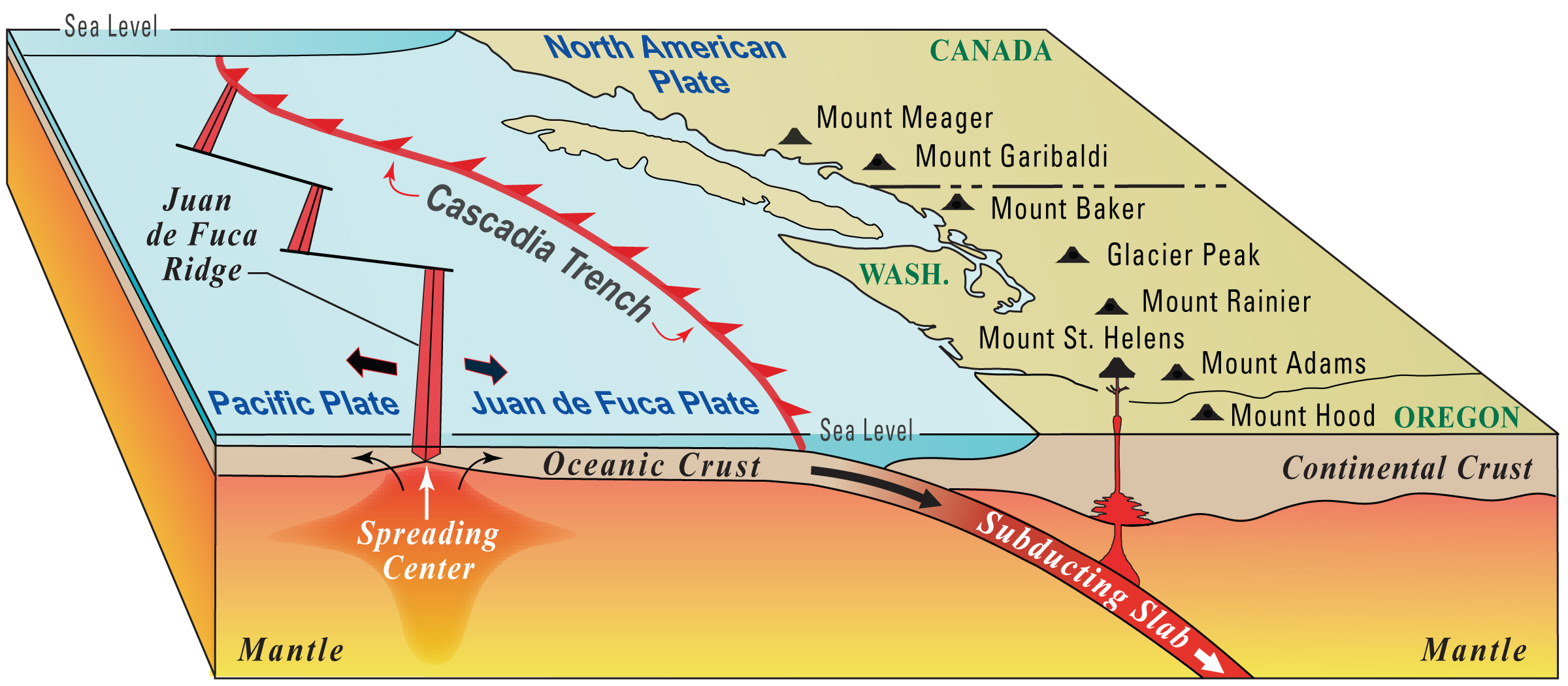
photo credit: USGS
During subduction, both original basalt and collected sediment of the Juan de Fuca Plate were scraped off and folded into layers onto the North American plate. The process formed today’s landscape, which began to rise above water about 12 million years ago.
As the plates ground together, The Juan de Fuca plate’s native basalts formed into what’s called the peripheral horseshoe that rings the north, east and south parts of the Olympic Mountains. The mountain ridge along the east side of the upper Dungeness River headwaters, ranging up to Mount Constance at 7700 feet (2347 meters), contains some of those basaltic peripheral rocks.
The core rocks of the Olympic Mountains originated from the sediment collected by the Juan de Fuca plate and scraped off onto the continental crust plate. Blue Mountain, rising 6007 feet (1831 meters) above the northeast corner of the Gray Wolf basin, is a sedimentary formation.
Faults at Hurricane Ridge and Gray Wolf Ridge mark the processes that separate the core rocks and the peripheral basalt. Subduction continues to add folds of material to uplift the land, while erosion continues to carry away the oldest sediments from the top.
Frozen
It has probably been less than 20,000 years since the Sequim area was covered by 4,000 feet of ice.
During the Pleistocene ice age (about 1.8 million to 12,000 years ago) as many as six major glaciations moved over the Olympic Peninsula, with ice sheets coming down from western Canada, receding, and returning.
Traces of the Possession Glaciation (about 80,000 years ago) are visible in the lowest layers of the bluff at Port Williams, east of Sequim. During the Fraser Glaciation (25,000-10,000 years ago), the ice sheet reached up the Dungeness River about 24 miles, nearly to Royal Creek, on its journey southward beyond what is now the city of Olympia and westward beyond Cape Flattery. Locally, Burnt Hill, Ned Hill, most of Deer Ridge and Bear Mountain were covered, with Mt. Zion and Maynard Peak nearly overtopped as well.
Hikers can see granite boulders above the 3600-foot level of Blue Mountain and Maynard Peak. Geologists conclude that the granite, which is not part of the peninsula’s native rock, was deposited by glaciers. The Gold Creek basin also contains glacial deposits, with other deposits just below the Forest Service road to the Upper Dungeness trailhead, along the canyon in the Three-O’Clock ridge area.

Deception Glacier (photo credit: Wikimedia Commons)
The Dungeness River’s wide valley may owe its shape to the glaciers: it was probably cut by glacial melt waters, perhaps even while the ice sheet remained overhead. A deep test well drilled northeast of Sequim showed more than 2,000 feet of glacial-related deposits above the bedrock. Other glacial material, carried downstream by the Dungeness River, can be found in the river’s alluvial deposits.
About 10,000 years ago, there occurred a global warming followed by several cooler periods. During one of these cool periods known as The Little Ice Age (1450-1890), many glaciers in the Olympics, including the Upper Dungeness Royal Basin glacier and the Gray Wolf glacier, re-established or extended their bases. Deception Glacier at the head of the upper Gray Wolf River is the main glacier still existing in the Dungeness River’s watershed.